Lloyd Crossing Sustainable Design Plan
Project Overview
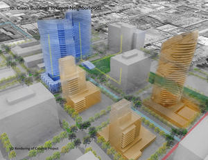
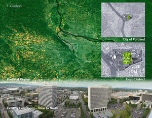
The Lloyd Crossing Sustainable Urban Design Plan integrates multiple sustainable strategies for energy, water, and habitat to transform and create a new identity for a 35-block, inner-city, commercial area of Portland. The plan lays out a new analytical, design, and economic framework for adding 8 million square feet of development over 45 years while dramatically improving the district's environmental performance. A four-block, mixed-use project, the Catalyst Project, will serve as a testing ground for key elements of the design plan.
Design & Innovation
Predesign
The initial design process included a competition that brought together the entire consultant team for the first design charrette. Within the first week, real estate analysts, branding specialists, landscape planners, urban designers, civil engineers, district and building energy specialists, and a contractor all came together with the architectural design team to brainstorm solutions for the district.
Design
Integrated process
After winning the competition, the team held multiple meetings with stakeholders and City agencies to understand the existing potential and the potential payback to the City by offsetting infrastructure costs with neighborhood sustainable strategies.
Metrics and payback
After initial goals had been set and the Predevelopment Metrics concept had evolved, there were many iterations of the strategy–payback cycle. Each idea or strategy was tested against the cost–benefit analysis for the district financial model. Benefit modeling included detailed analysis of the input and output flows of the district. These included carbon, water, solar energy, tree cover, etc.
Design integration
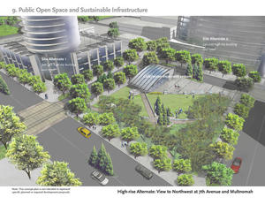
The most exciting step was combining the metrics, payback, and design and expressing the water, solar, and wind functions in the infrastructure forms. New forms were created for intersections, and wastewater treatment was included within the central urban space.
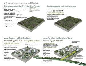
All of the Plan's key environmental strategies work toward the Predevelopment Metrics Goals in the categories of habitat, water, and energy. These goals provide the framework for evaluating and understanding the systemic nature of the interconnected design strategies.
Habitat quantity, quality, and connections will be improved by restoring habitat "patches" within the streetscape that connect to existing habitat corridors. Tree cover will increase from 14.5% in 2004 to 30% in 2050.
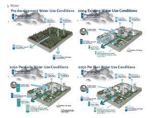
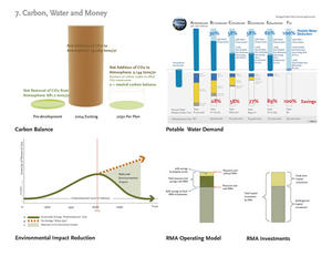
Potable water use will be reduced by 62% and annual fees will be reduced by 89% through an integrated water system that includes stormwater management and treatment, and graywater and blackwater treatment and reuse for nonpotable purposes.
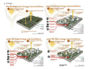
Energy demand will be reduced and onsite renewable energy resources, such as daylighting, wind power, photovoltaic systems, and biogas generation, will be harnessed. A shared "thermal loop" will balance heating demands among complementary uses. Solar utilization will increase from 2% currently to 13.7% in 2050, exceeding the pre-development utilization of 5%. The carbon balance will be reduced from 29,000 tons per year to 2,000 tons per year, despite the addition of 8 million ft2 of new buildings. Almost 90% of the power will come from renewable sources in 2050, and carbon neutrality will be achieved through the purchase of carbon credits.
Regional/Community Design
Land Use & Community
Existing transportation lines and utility infrastructure, stable commercial tenants, and the potential for residential and commercial development make this an ideal district within which to create a sustainable urban neighborhood.
Transportation
The study area is at the nexus of Portland's light-rail and bus network as well as a planned streetcar system. These networks provide the optimum opportunity to utilize mass transit, minimizing local air pollution and greenhouse-gas emissions. Surface parking for existing uses will be displaced by open space and future building development, and a portion of existing street parking will be displaced by stormwater, streetscape, and habitat strategies.
The district's existing Transportation Management Association has focused programs for improved public transit and ride sharing, alternative work-hour programs, and programs promoting parking management and bicycle and pedestrian measures.
Utility infrastructure
The neighborhood is well served by existing water, sewer, gas, and power infrastructure. The electrical infrastructure, however, is near some transmission limits and would benefit from reduced power consumption. The 35-block area is zoned Central Commercial with a Design Overlay Zone (CXd) and is part of the Oregon Convention Center Urban Renewal Area, which has been designated by the Portland Development Commission (PDC) for a tax-increment financing (TIF) program, administered by PDC. These TIF funds could be essential for creating the sustainable urban infrastructure.
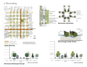
Placemaking and preserving urban density
The Sustainable Design Plan vision is to preserve all the potential development area within the neighborhood. Over time this will reduce the pressure on development in areas outside Portland's urban growth boundary. Such sites which have less developed infrastructure and are more sensitive environmentally. The plan also recommends a combination of strategies for street-level and upper-level land use, street hierarchy, open space, landscape and habitat, ground-level building character, and tower setback requirements that would create a vibrant, attractive urban neighborhood.
FAR transfer
In order to create vital open space and to preserve the floor-area-ratio (FAR) capacity of the study area, the plan recommends exploring the idea of a FAR transfer mechanism between selected sites in the neighborhood.
Land Use & Site Ecology
The habitat and tree-cover strategies will combine to form a small, mixed-conifer forest woven into the urban infrastructure. A layering of green streets, pedestrian streets, habitat corridors, and bioswales will create an integrated, urban streetscape.
Key habitat and tree-cover strategies include:
-Increasing overall canopy coverage by 25% to 30%;
-Implementing high vegetative structural diversity, both vertically and horizontally;
-Developing two acres of mixed-conifer forest “patches” in conjunction with “green streets”;
-Developing several acres of habitat corridor, providing connectivity between forest patches and Sullivan’s Gulch; and
-Restoring 50 acres of mixed-conifer forest offsite at the adjoining Sullivan’s Gulch.
The stormwater-management approach mimics predevelopment watershed characteristics by using the natural flow of the site to capture and treat stormwater in a system of bioswales at the downhill side of each block and intersection. All of the stormwater generated from the rights-of-way will be treated and recharged into the ground. This stormwater strategy will improve river water quality and reduce demand on Portland's combined stormwater and sewer system. It will also increase landscape and habitat areas, unify the streetscape design concept, and create a unique pedestrian experience.
All of the stormwater generated from private property, and not captured for reuse, will be treated and infiltrated on site with a variety of stormwater best-management practices.
Bioclimatic Design
Zoning will be modified to optimize solar exposure during buildout. The plan calls for detailed wind-flow and solar analysis of building massing and street exposure. Extensive natural ventilation and daylighting strategies will reduce the need for energy-intensive systems.
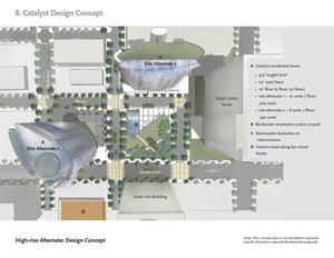
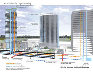
Buildings in the Catalyst Project are designed to respond directly to solar paths and wind patterns. The elliptical plan for the housing tower is designed to reduce perimeter area, optimize summer ventilation on the northwest axis, and use an offset elliptical solar screen to provide shading. The design team plans to locate 75% of windows on south and west elevations for best solar access. Most apartments will have dual exposures to maximize daylighting and natural ventilation and cooling.
Light & Air
The Sustainable Design Plan is designed to encourage and optimize natural ventilation and daylighting. Massing diagrams encourage offset towers for optimum wind and solar access. Offsetting the towers also creates viewshed opportunities to the Willamette River. The development goal is to exceed LEED(r) Platinum standards for indoor air quality, ventilation, and daylighting.
The narrow floor plates of the Catalyst Project office tower will take full advantage of cross ventilation, enable occupant views, and optimize daylighting. The elliptical floor plate of the residential tower will be oriented on a northwest axis to optimize wind speed and negative pressure at the exterior skin during summer months.
The Plan also includes additional indoor-environment strategies:
-Three-fourths of all windows will be located on south and west elevations for solar access;
-The residential building plan configuration will allow for dual exposures in most apartments to maximize daylighting and natural ventilation and cooling;
-Façade design elements will create passive-solar shading; and
-Daylight-sensing lighting controls will be utilized in all office areas.
Water Cycle
In order to reach the goal of living within the site’s annual rainfall budget of 64 million gallons, the plan recommends a 30% reduction in potable water use through efficient fixtures and, by 2050, the treatment and reuse of rainwater and blackwater for all nonpotable uses. This would result in a 62% reduction in water demand, compared to minimal compliance with code.
Water strategies within the Catalyst Project will include dual systems for supplying potable and reclaimed water, individual rainwater-harvesting systems, and a shared blackwater-treatment system to collect and treat all of the wastewater from the Catalyst Project and two existing office towers.
Energy Flows & Energy Future
The energy vision of the Sustainable Design Plan is to create a neighborhood in which the carbon balance and the use of incident solar energy equal or improve upon the predevelopment condition. The plan will increase the solar utilization from 2% today to 13.7% in 2050.
Load reduction
Reduced energy loads will lower total energy use as well as peak electricity demand. An efficiency factor of 6.1 is planned by 2050. Strategies include:
Optimal insulation levels in building envelopes;
Eliminated thermal bridging;
High-performance glazing and window systems;
Thermal mass;
Appliances and furnishings with superior energy efficiency;
Automatic controls for plug loads;
Water-efficient hot-water-using plumbing fixtures;
Daylight as the sole ambient light source;
Ultra-high-efficiency linear fluorescent task lighting;
“Dark campus” exterior-lighting controls;
Solid-state elevator drives with “smart” car controls; and
Variable-load controllers for escalators.
Renewable energy
As the study area is built out, building efficiency will generate increasingly significant savings. Photovoltaic and wind systems will not only save money, but will also present the district's sustainable identity to the larger community. A number of renewable-energy strategies are planned:
10 megawatts of photovoltaic (PV) capacity are planned through rooftop PV, south-facing PV wall cladding, PV window shades for south-facing glazing, and PV arrays lining a 3/4-mile stretch of Sullivan’s Gulch.
1.4 megawatts of wind-turbine capacity are planned through two small (five to ten kilowatt) vertical-axis turbines on the roofs of high-rise office towers and two large (600 kilowatt) horizontal-axis turbines mounted on 60-meter poles.
Biogas will be generated from waste processing in the study area.
The development will purchase wind power for all imported electricity and carbon-offset credits for all imported natural gas.
Materials & Construction
The materials vision of the Sustainable Design Plan is a neighborhood in which construction materials are evaluated and selected based on long-term energy efficiency and low embodied carbon-dioxide content, to contribute to achieving the goal of a carbon-neutral study area.
Methodologies will be developed as design of infrastructure and buildings begins.
Long Life, Loose Fit
Long-term adaptability and flexibility of systems is a key component of the Plan. The proposed plan anticipates a mix of residential, office, and commercial development and must provide a framework of energy, water, and habitat strategies that will work with each building type. All sustainable infrastructure strategies are designed to support high density.
One key idea is “interim retail buildings" — recyclable one-story steel structures that can be used to create street life and density in the short term and be relocated as soon as higher-density development becomes feasible. This plan will meet the urban design and livability goals while providing a building type with an extended shelf life.
"Open-source" energy systems are designed to interconnect mixed buildings and to accommodate a variety of uses over time. Building designs will accentuate durable exterior materials and exposed and "updateable" energy systems. Photovoltaic and solar hot-water systems will be integrated into buildings but also open systems so that elements can be replaced as technology develops.
Other Information
Cost and financing mechanisms are treated as design elements as critical as solar, wind, or water strategies. Real estate analysts were an integral part of the design team from the first day of designing a competition strategy.
Multiple strategies were utilized to create an innovative economic plan:
-Reinvest $9 million in savings each year from sustainable strategies to fund green infrastructure.
-Design a new economic entity, the Resource Management Association (RMA), to implement sustainable development strategies and identify sources of revenue to build and maintain green infrastructure throughout the study area.
-Use the 45-year cash flow — a district-wide summary financial model of water, energy, habitat, and placemaking infrastructure — as a key decision making tool.
-Work with marketing team members to create a unique sustainable identity — a brand — to aid in the marketing of the neighborhood.
-Create new public-private partnerships. A commitment to identifying public sources of capital is required to aid in short-term capital shortfalls. Tax-increment financing (TIF), local-improvement district (LID) revenue, federal incentives, system development charges, new market tax credits, and the reallocation of capital expenditures for regional infrastructure were all explored to fund the $380 million to build the sustainable infrastructure.
Creating the RMA
In order to create, design, and finance new district-wide green strategies, a new operational and funding mechanism will be required. A new entity call the Resource Management Association (RMA) was designed to implement the green strategies for this district as part of the Sustainable Urban Design Plan.
The RMA will engage in a variety of tasks, ranging from the financing and coordination of public grants to the implementation of district-wide energy and water plans and the creation of green infrastructure. A key concept of the RMA is to use the incremental savings from the high-performing energy and water systems to finance the capital costs for new green infrastructure throughout the district.
Payback analyses
The district-wide summary financial model identifies payback periods for water and energy systems, habitat and open space, and placemaking infrastructure. Water and energy systems have the shortest payback periods, and the subsequent revenue will be used to pay for the habitat, open space, and placemaking infrastructure. All infrastructure will be paid off and generating revenue by the end of the study period, assuming reinvestment savings by all development stakeholders.
When this project began, neither the PDC nor the consultants knew whether it was possible to achieve a development that was both environmentally and financially sustainable, much less one that met our very aggressive performance standards. We learned that, through an integrated approach, we could conceive a plan that meets the highest level of environmental performance, generates positive returns, and creates a unique urban neighborhood. Even though implementation of the vision will require strong public-private partnerships, patient investors, and a long-term perspective, the plan has already generated support and excitement.
One of our biggest challenges was creating integrated habitat plans for an urban district. Urban ecosystems with enhanced open space and landscaped streets exist in other locations, but optimizing conditions and design parameters for a "steady state" urban wildlife population is a concept that has not been fully tested. Creating future citywide networks for habitat connections will be key to optimizing the ecological diversity within open space preserved through growth-management practices in Portland.
Additional Images
Project Team and Contact Information
| Role on Team | First Name | Last Name | Company | Location |
|---|---|---|---|---|
| Architect (Project manager) | Richard | Franko | Mithun Architects + Designers + Planners | Seattle, WA |
| Architect (Catalyst leader) | John | Thomas | Mithun Architects + Designers + Planners | Seattle, WA |
| Owner/developer | Sloan | Schang | Portland Development Commission | Portland, OR |
| Civil engineer (Water systems and stormwater strategies) | KPFF Consulting Engineers | Portland, OR | ||
| Landscape architect (Landscape and habitat strategies, street sections) | Mike | Abbate | GreenWorks, PC | Portland, OR |
| Energy consultant (Neighborhood energy analysis and strategies) | Mike | Hatten | SOLARC Architecture and Engineering, LLC | Eugene, OR |
| Real estate and financial analysis | Laura | Lohman | Heartland | |
| Urban design | Joseph | Readdy | Urbsworks, Inc. | Portland, OR |
| Mechanical engineer | Jerry | Yudelson | Interface Engineering | |
| Electrical engineer | Ian | Theaker | Interface Engineering | |
| Identity | Jon | Lee | ID, Inc. | |
| Cost estimator | Walsh Construction Company | Portland, OR |


